


More than 65 million people in the affected areas are under winter weather alerts, the National Weather Service said.
Rain, snow, sleet, and freezing rain — or a combination of all of those — will make travel difficult over the three-day holiday weekend across the Eastern US.
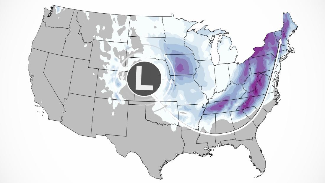
A swath of 8 to 12 inches of snow was recorded across portions of North Dakota on Friday.
From there, the system dove deeper south, heading into Missouri, Arkansas and Kansas where it delivered rain and snowfall.
Throughout Saturday the storm system will bring heavy bands of snowfall to the Mid-South and Tennessee Valley.
Localized areas of Tennessee could see snow totals exceeding 6 inches as the storm continues its eastward track toward the Southern Appalachians.
Southeast may get a mix of everything
For much of the Southeast, the system will begin in the form of rain on Saturday.
As the temperatures rapidly drop behind a strong cold front, rain will change into freezing rain, sleet and eventually snow for many locations across the Southern Appalachians by Saturday evening.
States of emergency were declared by governors in Georgia, North Carolina, South Carolina and Virginia, allowing assets and resources to be positioned ahead of the storm’s arrival.
Georgia Gov. Brian Kemp ordered the state Department of Defense to prepare 1,000 National Guard troops to assist in the response to the storm.
In South Carolina, Gov. Henry McMaster urged residents to monitor local weather forecasts and take precautions.
Major cities including Atlanta, Greenville, Charlotte, and Raleigh are included in winter weather alerts in effect through Monday.
Forecasting winter weather in the Southeast is never easy, as timing often comes down to the wire.
“These different types of wintry precipitation are very sensitive to small changes,” said Kyle Thiem, a meteorologist at the NWS office in Atlanta. “A change of just a degree or two can mean the difference from relatively harmless rainfall to very impactful ice and snow accumulations.”
However, it is the slow forward speed of this system that provides the setup for a crippling ice storm that could knock out power to millions.
Ice storm impacts could be seen from northeast Georgia to southern Virginia Saturday night through early Monday morning.
Cities including Charlotte and Columbia are forecast to see ice accumulations of a quarter to a half an inch through Sunday night, alongside wind gusts of up to 30 mph likely to take down trees and power lines in the region.
The National Weather Service has issued an ice storm warning for portions of northeast Georgia, South Carolina and North Carolina, in effect through early Monday morning in advance of the system, with temperatures likely to remain sub-freezing until the start of next week.
In the southern Appalachian Mountains, the snow totals will go up as quickly as the elevation does. Asheville, North Carolina, for example, is forecast to pick up 8-12 inches, but could reach 20 inches at elevations above 4,000 feet.
Mid-Atlantic and Northeast
The storm will turn northeastward to the East Coast on Sunday and Monday, with heavy snow of more than a foot expected in some locations.
Some snow will fall in the major metro areas of Washington, DC, Philadelphia, New York and Boston, but a change to rain will hold down the accumulations.
Snowfall intensity in the region may be heavy enough to evade significant icing, but NWS Baltimore warns that untreated surfaces may still lead to dangerous travel conditions where ice accumulates.
The majority of accumulating snowfall will occur Sunday afternoon through Monday morning.

Interior cities such as Charleston, Pittsburgh, Buffalo, Syracuse and Burlington, Vermont, will see the heaviest snow.
Prior to the snow event moving into the region, the Northeast will experience cold temperatures and dangerous wind chill.
Wind chill alerts are in effect for nearly 20 million people Saturday, as feels-like temperatures could drop as low as 40 to 45 below zero in parts of the Northeast.
Alongside the snowfall potential, strong winds from the east associated with the storm system could cause major coastal flooding of up to 3 feet above ground in some areas along the Northeast coast during high tide.
The timing of winds shifting from the east to the south will largely determine the severity of flooding, with moderate flooding potential if winds shift prior to high tide.
“Widespread moderate to locally major flooding of vulnerable areas is possible near the waterfront and shoreline, including roads, parking lots, parks, lawns, and homes and businesses with basements near the waterfront,” the NWS in New York, NY said Saturday.
Inundation could cause road closures and structural damage along the Atlantic coastline.
CNN Meteorologists Allison Chinchar, Chad Myers, Dave Hennen, Monica Garrett, and Haley Brink contributed to this story
More News
What to Know About Venice’s Fees for Day Trips
U.S. Economy Grew at 1.6% Rate in First Quarter Slowdown
Opinion | The Looming Decision That Could Get Pro-Choice Voters to the Polls