


CNN
—
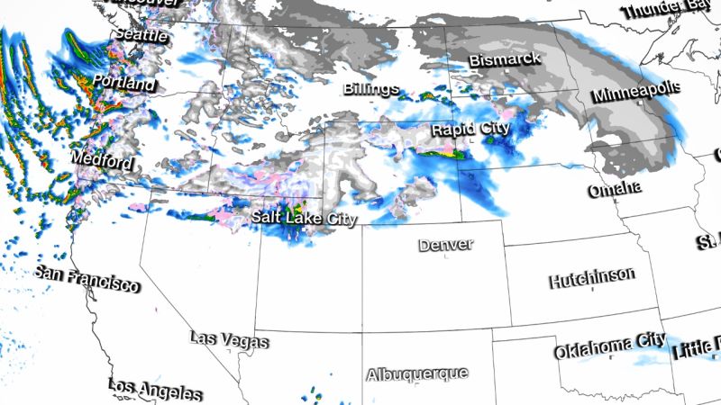
A massive winter storm poised to lash much of the US this week, will bring a mix of heavy snow and rain along with gusty winds – and has put more than 40 million people across 22 states under winter weather alerts Tuesday.
The alerts stretch from the West Coast through the Midwest and to the New England coast. The main impacts Tuesday are expected to be in the West and Midwest, including Minneapolis, where the first round of historic snowfall is possible.
Snow totals between 1 and 2 feet – possibly higher in some areas – are expected for most of the mountain ranges across the West, according to the National Weather Service.
Lower elevations across parts of parts of Northern California could see up to 6 inches of snow. And interior valleys can expect to see a lighter mix of rain and snow, the weather service added.
In addition to the snow, wind gusts of 50 to 60 mph are expected to impact a large swath of the West, and some places could see up to 80 mph gusts, the weather service said.
A blizzard warning is in place for portions of Wyoming, Montana, South Dakota, Iowa and Minnesota, according to the weather service.
“As impressive as the snowfall event will be across the West, potentially even more impressive and impactful will be the blizzard that is expected to develop from the High Plains through the Upper Midwest, especially Wednesday and Thursday,” the Weather Prediction Center wrote in a forecast discussion Tuesday morning. “By late Tuesday night and more exceptionally on Wednesday, the major winter storm will take shape and spread tremendous snowfall, both in coverage, rates, and amounts, across the High Plains and Upper Midwest.”
Snowfall rates of 1 to 2 inches per hour are possible on Wednesday. This combined with strong winds of 40 to 50 mph will create blizzard conditions which will make travel across the region difficult to impossible and could lead to power outages.
More locally, snowfall is expected to be historic for Minneapolis this week, as multiple rounds through Thursday are forecast to bring accumulation of more than 2 feet – with the addition of strong wind gusts of 50 mph by Wednesday.
The storm could become one of the top 3 all-time snowfall events for Minnesota, the prediction center warned.
The first round of snow Tuesday could bring up to 7 inches of snowfall in Minneapolis. The second snowfall round is expected to begin Wednesday afternoon and last through Thursday, when another 10 to 20 inches could fall. The three-day total could be between 18 and 25 inches.
Overall, a wide area across the Midwest can also see between 1 and 2 feet of snow through Thursday, with some areas possibly topping 2 feet.
As part of the same system, rain and thunderstorms are forecast across the Midwest and Plains late Tuesday night into Wednesday, the prediction center said. The Upper Midwest could also see heavy rainfall and severe storms beginning Wednesday.
A slight risk for severe storms, Level 2 of 5, has been issued for central and eastern Oklahoma and into much of central Missouri, including Oklahoma City, Tulsa and Springfield. The main threats are damaging winds, isolated large hail and a possible brief tornado.
A marginal risk for severe storms, Level 1 of 5, surrounds the slight risk areas and extends from northern Texas to western Illinois. The main threats are damaging winds and a brief tornado.
The storms can also bring heavy rainfall from eastern Oklahoma and western Arkansas through Missouri to northern Illinois, southern Michigan, northern Indiana and northern Ohio.
The heaviest rainfall is likely to be from northeastern Missouri to southwestern Michigan, where 2 to 4 inches of rain are possible.
More News
How a Playboy Model’s Story of an Affair With Trump Became a Commodity
Harvey Weinstein’s Conviction Was Fragile From the Start
Chaos and Oppression