


CNN
—
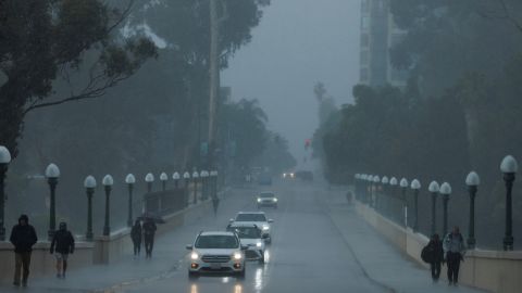
A giant winter storm cutting through the US is bringing severe weather, with dangerous blizzard conditions in the Great Plains, icy weather in the upper Midwest and severe storms along the Gulf Coast Tuesday.
There are more than 10 million people across 17 states under winter weather alerts as the massive storm continues to head east.
The coast-to-coast storm – which walloped the West over the weekend – is expected to strengthen as it pushes eastward Tuesday, and stall across the central Plains into Thursday, snarling travel amid blowing snow and freezing rain.
Meanwhile, the southern end of the storm is expected to bring late-season tornadoes along with strong thunderstorms.
Here’s what different regions can expect in the coming days:
- Parts of the Great Plains could see severe thunderstorms, heavy downpours and flash flooding.
- With snow expected to fall at rates of 1-2 inches per hour amid powerful 40 mph winds, blizzard conditions are expected for parts of the central and northern Plains Tuesday and Wednesday.
- The Storm Prediction Center forecasts a risk of tornadoes, large hail and damaging straight line winds from eastern Texas into northern Louisiana and southwestern Mississippi.
- A tornado watch has been issued for parts of Texas and Oklahoma until 4 a.m. A couple of tornadoes are possible, as well as ping-pong-sized hail and wind gusts up to 75 mph.
- The greatest flash flooding threat will be from the lower Mississippi Valley into the central Gulf Coast, Tennessee Valley and southern Appalachians from Tuesday into Wednesday.
- Freezing rain and sleet will be possible in the upper Midwest through Wednesday.
The storm, which first hit the Western US with much-needed snow and rain, resulted in winter storm alerts stretching from the Canadian border to the Mexican border.
In Denver, up to 5 inches of snow is expected and 50 mph wind gusts are possible.
Blizzard warnings extend from just west of Denver into the Dakotas, where harsh life-threatening conditions are expected.
Some areas inside the blizzard warnings could receive as much as 20 inches of snow, with winds strong enough to knock down tree limbs and cause power outages.
Blizzard conditions will “ramp up” overnight in the upper Midwest, and central Plains as residents brace for “a long drawn out period of snowfall,” according to Brandon Wills, a meteorologist for the National Weather Service in Cheyenne, Wyoming.
“We’re not expecting a quick burst of snowfall here,” Wills said in a Monday evening update. Snow is “going to accumulate the highest in the northern Nebraska panhandle – and it’s going to be blowing around like crazy because of the strong winds that we’re going to have as well,” he said.
Up to 16 inches of snow and 60 mph wind gusts are possible in Scottsbluff, Nebraska.
The National Weather Service office in Rapid City, South Dakota, said travel through the area will be nearly impossible Tuesday and Wednesday, and possibly into Thursday.
Interstates in South Dakota could become impassable amid the blizzard conditions, resulting in roadway closures across the state, the South Dakota Department of Transportation warned Monday.
Ice accumulation is possible across southwestern Minnesota and western Iowa, where as much as a tenth of an inch of ice could develop.
In Minnesota, the National Weather Service issued various winter weather alerts, including a winter storm warning, an ice storm warning and a winter weather advisory. The Minnesota Department of Transportation said in a tweet Monday, “Challenging winter weather could impact travel statewide all week.”
In Anchorage, Alaska, an “unprecedented amount of snowfall” has led to schools being closed for four days and shut down the University of Alaska Anchorage and Alaska Pacific University on Monday.
“The snowstorms that have hit Anchorage over the last week are historic in nature, bringing anywhere between 30-45 inches of snow to our city,” said Hans Rodvik, a spokesperson for the Anchorage mayor’s office, said in a statement to CNN Monday.
Meanwhile, the southern end of the storm threatens to bring tornadoes.
A tornado watch is in effect for parts of Oklahoma and Texas until 4 a.m. Tuesday. The main threats are tornadoes, hail and wind gusts up to 75 mph.
An enhanced risk of severe weather, level 3 of 5, was issued for eastern Texas and the lower Mississippi River Valley Tuesday, with the main threats including powerful tornadoes, damaging winds, and large hail. Shreveport, Alexandria, and Monroe, Louisiana, are all part of the threatened area.
There’s also a slight risk, level 2 of 5, the storm could bring tornadoes, strong winds, and large hail to Dallas, Fort Worth, and New Orleans. Isolated tornadoes, large hail, and damaging winds are possible in Houston, Memphis, and Little Rock.
In total, more than 25 million people could experience some sort of severe weather.
Tuesday also brings a risk of flash flooding due to excessive rainfall “from far east Texas into the lower Mississippi Valley,” warns the Weather Prediction Center. Up to 4 inches of rain could fall.
On Wednesday, the threat for severe weather is largely focused on the Gulf Coast.
The main threats are expected to be possible strong tornadoes, damaging winds and hail in New Orleans, Baton Rouge and Mobile, Alabama. There is also a slight risk for excessive rainfall, “from the central Gulf Coast into the southern Appalachians,” the Storm Prediction Center warns.
An additional 2-4 inches of rain could fall across parts of Louisiana, Georgia, Alabama, Mississippi, Tennessee, and North Carolina.
These areas need the moisture and have seen great relief to drought conditions in the past week. Tennessee, for example, went from 96% of the state under drought to being at 46% this week.
More News
Barnard Ends Suspensions for Most Student Protesters Who Were Arrested
What Weinstein’s Overturned Conviction Means for His California Case
G.O.P. Asks Secret Service to Move Protesters Away From Convention Venue