


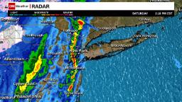
The watch includes New York City and parts of southeast New York, Connecticut, parts of northern New Jersey and Rhode Island.
An intensifying line of thunderstorms over northern New Jersey is expected to track eastward across the watch area Saturday afternoon, posing a risk of damaging wind gusts of up to 75 mph.
Brief, isolated tornadoes are also possible, as well as up to quarter-sized hail.
The National Weather Service issued a tornado warning for Suffolk and Nassau counties, on Long Island, until 3:30 p.m. ET. On Saturday, a thunderstorm capable of producing a tornado was located over Levittown and could impact Farmingdale, Plainview and Deer Park.
The weather service also issued a severe thunderstorm warning earlier Saturday including all of New York City and parts of northeast New Jersey. Storms moving through the area could produce powerful wind gusts, strong enough to cause damage to trees and power lines.
New York City Mayor Bill de Blasio warned Saturday the city could see “some strong rain, wind gusts up to 40 MPH and even hail between … 2-4 PM.”
More News
Columbia’s University Senate Calls for an Investigation Into the Administration
Opinion | The Student-Led Protests Aren’t Perfect. That Doesn’t Mean They’re Not Right.
5 Takeaways From the Second Week of Donald J. Trump’s Criminal Trial