


This developing storm system will usher in enough cold air to create snow farther to the north. A snowstorm with significant impacts is forecast across the upper Midwest from Thursday evening into Friday.
“Much of the Upper Midwest is under some sort of winter alert as the season’s first significant snowfall is forecast,” CNN meteorologist Dave Hennen says.
Total snow accumulations will range from only 2 to 6 inches. But the winds will gust as high as 55 mph, creating whiteout conditions in portions of the Plains.
A blizzard warning is in place until Friday evening and covers most of northeast South Dakota.
“Travel should be restricted to emergencies only,” says the National Weather Service. “If you must travel, have a winter survival kit with you. If you get stranded, stay with your vehicle.”
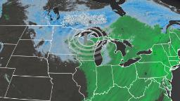
“On Thursday, the snow will march southward over the Northern Plains, the Upper Mississippi Valley, and parts of the Middle Mississippi Valley by Friday afternoon,” the Weather Prediction Center (WPC) says.
You may think it’s too early in the season to talk about snow, but if you’re across the upper Midwest, it’s pretty punctual, if not a few days early. Take, for example, Minneapolis/St. Paul, where the first snowfall of 1 inch or greater occurs around November 16. This Friday, the region could experience “numerous snow showers” that may be “heavy at times,” according to the Twin Cities National Weather Service office.
“Overnight Friday, light snow will move into parts of the Ohio Valley and the Great Lakes, as the snow over the Upper Mississippi Valley tapers off.”
Heavy rain threat moves Northeast by the weekend
After the storm gives many their first taste of winter across the upper Midwest, it will continue to expand in size and move slowly eastward. The front half of the low pressure will draw precipitation and milder temperatures northward, allowing the threat for locally heavy rain from the Ohio Valley to New England.
“As the system moves eastward, moisture from the Atlantic will stream into parts of the Northeast on Friday. The rain, heavy at times, will move into the Northeast/Mid-Atlantic and the Carolinas,” says the WPC.
This is why they have issued a marginal risk of excessive rainfall over parts of the Northeast on Friday into Saturday morning.
Rainfall totals will range between 1 to 2 inches through the early weekend. Still, localized accumulations could reach 2 to 4 inches across southern New England.
Some of this rainfall could fall in only a matter of hours, increasing that risk for flash flooding.
“The associated heavy rain will create localized areas of flash flooding, affecting areas that experience rapid runoff with heavy rain,” the WPC says.
Temperatures behind this storm system will plummet 15 to 25 degrees by the weekend for many East Coast cities, just enough to remind us that winter is right around the corner.
More News
Uvalde Families Sue Instagram and Activision Over Promotion of Guns
Lloyd Austin to Undergo Procedure to Address Bladder Issue
A Mexican Taco Stand Goes From Local Favorite to Michelin Darling