


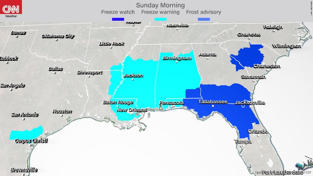
But the intense storm will bring plummeting temperatures and frigid air from Canada all the way down to the Gulf Coast. Locations from Louisiana to South Carolina and southward into Florida are expecting a freeze Saturday night into Sunday morning. Many of these locations will experience a hard freeze, with several hours below 28 degrees.
Low temperatures in the low to mid 20s and below freezing for a significant duration in much of the Deep South will threaten the vulnerable vegetation.
“Freeze conditions will kill crops, other sensitive vegetation and possibly damage unprotected outdoor plumbing,” the National Weather Service (NWS) in Birmingham, Alabama, said.
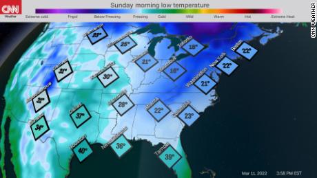
More than 30 record lows are possible Sunday morning from Louisiana to central Florida and as far north as the Mid-Atlantic. Temperatures will be in the teens for the Tennessee Valley into the Mid-Atlantic and Northeast, but freeze warnings are not issued for these locations because the growing season has not begun.
Flood watches are in effect Friday through Saturday morning in northern Florida and southern Georgia, in part because the soil was already saturated from days of rain. Rainfall of 3-6 inches are forecast across this same area Friday through Saturday morning.
Mid-Atlantic braces for severe storms
Strong thunderstorms are possible in the Mid-Atlantic Saturday as the system spins northeastward. Some of these storms could create tornadoes, bringing dangerously damaging winds.
There is an enhanced (Level 3 of 5) threat for severe storms from Norfolk to Savannah through midday Saturday, and a slight (Level 2) risk extends into central Florida.
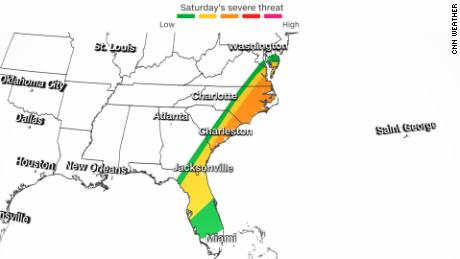
Periods of heavy rain, strong winds, and hail are possible and even an isolated tornado could appear, the NWS office in Charleston, South Carolina reported.
“A strong line of thunderstorms is forecast to move through the forecast area in the early morning hours. As the cold front approaches the region, frequent gusts into the 25-30 mph range are expected as sunrise approaches,” the Charleston office added.
Bomb cyclone roars across Eastern Seaboard
And farther north, the system is expected to strengthen into a bomb cyclone Saturday and bring damaging winds and heavy snow, especially to parts of the interior Northeast, making travel treacherous.
About 4 to 6 inches of snow are possible in the Tennessee and Ohio River Valleys, with more than a foot possible in parts of upstate New York and northern New England. A blizzard warning is also in effect until mid-afternoon Saturday for portions of northern Virginia across the Blue Ridge.
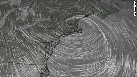
Metropolitan areas along the coast, including Washington, DC, Philadelphia, New York and Boston are expected to collect mostly rain, though some snow could fall before Sunday. More than 60 million people were under winter weather alerts from the NWS late Friday, stretching from Texas to Maine.
New York state activated its Emergency Services’ Operations Center Friday night ahead of the impending storm.
“With up to a foot of snow forecast in some locations, this system is expected to create dangerous travel conditions throughout the next 36 hours, and New Yorkers should do their best to stay off the roads during this time.,” Division of Homeland Security and Emergency Services Commissioner Jackie Bray said Friday in a news release.
The midsection of the country will see temperatures 30 degrees below average from Texas to Minnesota and single-digit wind chills across the Great Lakes and Northeast into the weekend.
CNN’s Jason Hanna, Aya Elamroussi and Derek Van Dam contributed to this report.
More News
Hamas Claims Rocket Attack That Closes Key Crossing Between Israel and Gaza
Dozens Are Arrested in Pro-Palestinian Protest at Art Institute of Chicago
Interstate 95 Reopens After Damaged Bridge Is Demolished