


CNN
—
A powerful storm packing hurricane-force wind gusts is expected to bring torrential rain and enormous waves to Alaska’s west coast this weekend, threatening to cause major flooding and beach erosion.
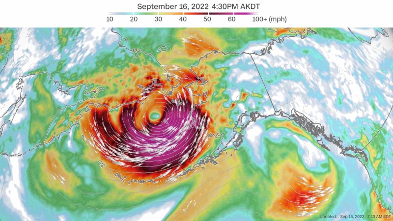
The system – the remnants of Typhoon Merbok – has been described by forecasters as “the strongest storm in over a decade” as it moves over the Bering Sea, which spans the northern Pacific Ocean between Alaska and Russia.
“This is a dangerous storm that is expected to produce widespread coastal flooding south of the Bering Strait with water levels approaching levels not seen in nearly 50 years,” the National Weather Service warned in a forecast Thursday.
Along Alaska’s shore, the main threats are a double-whammy of coastal flooding and winds up to 60 mph with higher gusts that could displace loose objects, damage buildings and bring down powerlines.
Weather officials in Alaska also urged residents to prepare for the storm as it could threaten to overwhelm critical infrastructure and wash away roads. The storm’s impacts are expected Friday through Sunday morning, with water levels rising the highest Saturday.
“Some locations may experience their worst coastal flooding in nearly 50 years. Peak water levels will persist for 10 to 14 hours before water recedes,” the weather service in Fairbanks, Alaska, warned.
Some areas including Savoonga, Diomede and the Bering Strait could see those conditions along with even higher wind gusts of 90 mph. Other areas at risk are the Chukchi Coast and Kotzebue Sound, the weather service in Fairbanks said.
Coastal flood watches have also been issued for all coastlines along the west coast of Alaska between just north of the Arctic Circle down through the Kuskokwim Delta coast.
The last time Alaska saw a storm this strong was in 2011, when it left behind a wide swath of destruction. Like Merbok, the 2011 system was an extratropical storm. An extratropical storm or cyclone has cold air at its core – unlike a tropical storm or cyclone which has a warm core. Both can cause significant damage from strong winds, heavy rain and storm surge.
“When a big storm comes in, we always say ‘does it compare to the 2011 storm?’” Jonathan Chriest, a meteorologist with the weather service in Fairbanks, told CNN. “This is the first storm since 2011 that we have high confidence … will compare impact-wise.”
On Friday, the remnants of Merbok are forecast to move into the Bering Sea and “bomb out” in a process also known as bombogenesis, referring to a pressure drop of 24 millibars in 24 hours or less. That means the storm is rapidly strengthening and has the potential to cause significant damage.
“Winds will peak early Saturday morning near Shishmaref, and during the day Saturday near Kotzebue and the Chukchi Coast,” the weather service said. “Coastal flooding will occur, in addition to significant beach erosion.”
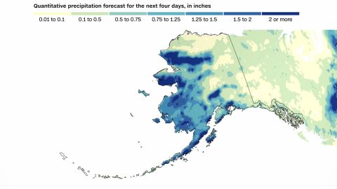
While most areas will see around 1 inch of rain with this storm, some areas could pick up as much as 2 to 3 inches through the weekend. Even if Anchorage picks up 1 to 2 inches from this storm, it will push this year into the top five wettest years on record.
More News
Last of Escaped Zebras Captured With White Bread, Oats and ‘Positivity’
The Bleak Life of a Deposed President and His Wife, Held Captive
Frank Stella, Towering Artist and Master of Reinvention, Dies at 87