


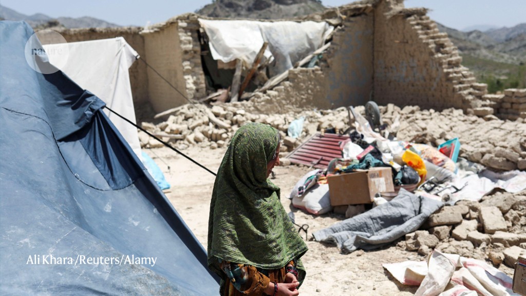
An earthquake in Afghanistan in late June has killed more than 1000 people.Credit: Ali Khara/Reuters/Alamy
Two weeks after a deadly earthquake hit central-eastern Afghanistan, researchers are still trying to pin down important details about the event, which could help to assess the risk of future tremors in the region.
The magnitude 5.9 earthquake struck at 1:24 AM local time on 22 June near the city of Khōst, which is close to the Pakistan border. The quake and its aftershocks have killed more than 1,000 people and destroyed thousands of homes. But the region has few seismic-monitoring stations, and security concerns and access issues have kept researchers away.
“If this earthquake had happened in Europe, we would have gone there immediately — the day of the earthquake,” says Sofia-Katerina Kufner, a geoscientist at the Karlsruhe Institute of Technology in Germany. “Speed is so important.” Kufner and her colleagues would have used mobile seismic stations to study the aftershocks and identify precise details about the location of the event.
But with sparse seismic data and limited ground observations, researchers are relying more on images taken from space to study the Afghanistan quake and work out where the next one could strike. “We do what we can with remote data, but the results will be far less precise,” says Kufner, who plans to use the satellite information.
Researchers say the devastation is unusual for a magnitude 5.9 earthquake. It was probably caused by the large number of vulnerable buildings in the area, along with the quake’s shallow depth, which is estimated at less than 10 kilometres. This resulted in more intense shaking closer to the Earth’s surface. The timing of the tremors — at night, when many people were asleep in their homes — also contributed to the huge death toll. “5.9 is just a tiny event and it should not kill people,” says Rebecca Bendick, a geophysicist at the University of Montana in Missoula. “If the infrastructure were better, people wouldn’t have died. If the earthquake were deeper, people wouldn’t have died. But that combination of the two was deadly.”
Unmapped area
With few seismic stations in the region, estimates of where the earthquake started underground are less precise. The closest seismic station is in Kabul, some 160 kilometres away, followed by one 350 kilometres away near Islamabad, Pakistan, and the rest are all more than 500 kilometres distant.
Paul Earle, a seismologist who manages the US Geological Survey’s National Earthquake Information Center (NEIC) in Golden, Colorado, says the centre’s estimate of the hypocentre falls within a 15 kilometre area. If the earthquake had happened in California, where there are some 950 operating stations, it would be within 1–2 kilometres. Accurate location data help emergency services to understand the affected area more quickly, he says.
The seismic data that are available suggest that the earthquake was the result of two sides of a fault grating against each other in a horizontal ‘strike-slip’ movement. But it is not clear from that data how and in which direction the rupture propagated — information that would help to identify areas that are now at increased risk of tremors.
One problem is that the earthquake hit in a poorly understood tectonic area, at the boundary between the Indian and Eurasian plates. This region has so many sub-faults and small, unmapped fault traces that it is difficult to identify the exact fault line, says Kufner.
It could take months to get detailed geological reports from the ground, such as evidence of changes to the Earth’s surface caused by the earthquake, and these could be washed away by heavy rains, says György Hetényi, a geophysicist at the University of Lausanne in Switzerland.
Limited resources
When the Taliban seized power in Afghanistan in August 2021, the international community responded by suspending funding to the country, including for research. The lack of funding, subsequent exodus of Afghan researchers and limited capacity of those still in the country has further hampered efforts to study the earthquake, say scientists.
Najibullah Kakar, a geohazards scientist at the GFZ German Research Centre for Geosciences in Potsdam, says his colleagues in Kabul are trying to get another seismic station back up and running in the city, but cannot access funds to fix damaged equipment. A temporary network of sensors designed to measure tectonic motion that Kakar and Bendick helped to set up in the country’s northeast in 2016 has also been destroyed and offline since 2021. Kakar hopes the international scientific community will find a way to help “keep the work alive”.
Without ground observations, Bendick thinks researchers will struggle to learn much about the earthquake from satellite data, because it’s not useful for deciphering low-magnitude tremors. “No one will really be able to work on that earthquake, because of the security and access issues,” says Bendick.
But others say that satellite images have already helped to clarify details about the quake. Radar data released last week from instruments aboard several satellites suggest that the rupture propagated from the epicentre in a south-southwest direction, and that it caused a few dozen centimetres of deformation on the Earth’s surface, pointing to a very shallow earthquake, says Hetényi.
More News
Who will make AlphaFold3 open source? Scientists race to crack AI model
These crows have counting skills previously only seen in people
Seed-stashing chickadees overturn ideas about location memory