


CNN
—
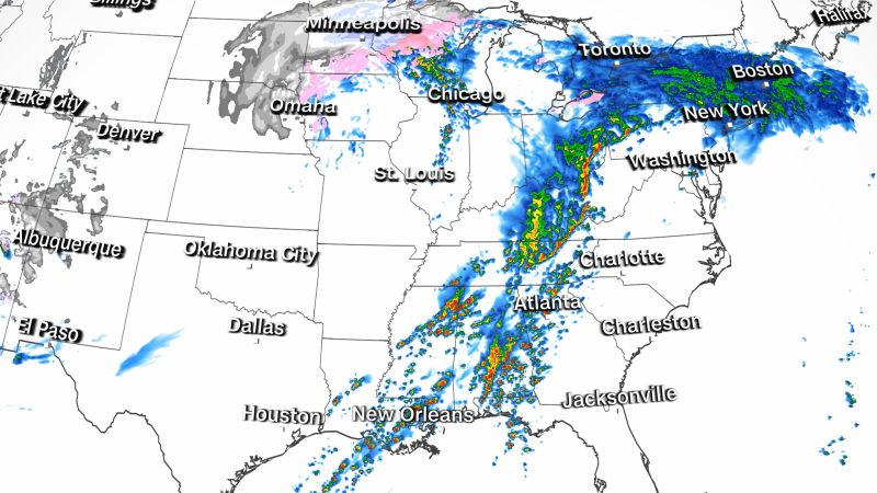
A major multi-hazard storm barreling across the country is bringing the risk of strong tornadoes and flooding to the South, and ice and snow to the Plains and Upper Midwest Tuesday.
The storm, which already brought deadly floods to California, was expected to pull moisture off the Gulf of Mexico into the South, where above normal temperatures have set the stage for severe thunderstorms.
Over 2 million people were under tornado watches across parts of Texas, Louisiana, Mississippi, Arkansas and Oklahoma as of Monday night.
On top of the risk of tornadoes, the areas could see hail and powerful scattered wind gusts up to 70 mph.
There’s already been damage reported after a possible tornado in Jessieville, Arkansas, according to Garland County officials.
“Damage was sustained to areas of the school due to trees, and power lines. The school was currently in session at the time, however all students have been accounted for and reports of no injury,” the Garland County Sheriff’s Office said in a release.
In Jackson Parish, Louisiana, residents were told to stay off the roads as the severe weather toppled trees and covered roadways with water. Jackson Parish Sheriff’s Department said tarps will be given out to those whose homes are damage.
“We are trying to work to get to houses that are damaged and clear roads,” the Sheriff’s Department said.
As the risk persists, forecasters have been concerned about tornadoes forming at night, according to Brad Bryant of the National Weather Service office in Shreveport, Louisiana.
“You can’t see them coming. A lot of the time, people are asleep and not paying attention to the weather,” Bryant said. “Many areas around here don’t have good cell phone coverage and storm alerts are not as effective in those areas, especially once people are asleep.”
Anyone in areas at risk of tornadoes should seek safe shelter immediately, Bryant said.
“If you wait around for a warning to be issued, it is too late,” Bryant said Monday. “You need to have a safe shelter plan in place in advance of these storms.”
By 1 a.m., there had been 21 storm reports, including one tornado report, 16 wind reports and four hail reports. The tornado that was reported was in Jonesboro, Louisiana, where large trees were knocked downed and damaged.
Damage reports were also coming from across northern Louisiana, including several transmission highline towers being damaged in the Haile community in Marion. One of the towers was knocked over and several others are damaged, according to the National Weather Service in Shreveport.
A wind gust of 81 mph was reported in Adair, Oklahoma – a category 1 hurricane equivalent wind gust.
Heavy rainfall is also accompanying the severe storms, creating the threat of flash flooding across North Louisiana, Southeast Arkansas and Northwest Mississippi, according to the National Weather Service.
More than 12 million people across the south are were under flood watches Tuesday morning, with the heaviest rainfall expected in parts of southwest Alabama and southeast Georgia. Flood watches spread from the Texas-Louisiana border north along the Mississippi River Valley into southern Indiana and Illinois.
Rainfall totals across the South through Wednesday are forecast to be between 2-4 inches and some areas could see up to 6 inches.
A radar-indicated flash flood warning has was issued for parts of central Arkansas, including much of Little Rock, until 12:55 am CST. Between one and two inches have fallen in the area, and another one to two inches are possible.
“Turn around, don’t drown when encountering flooded roads. Most flood deaths occur in vehicles,” the National Weather Service warned.
In response to the severe weather and flash flooding expected in parts of Texas, Gov. Greg Abbott activated state emergency response resources Monday.
“As we monitor conditions and potential threats, I urge Texans in affected areas to heed the guidance of local officials and remain weather-aware as severe weather systems develop,” Abbott said in a statement. “We will swiftly provide all necessary resources to address severe weather and protect our communities.”
Meanwhile, waterlogged Northern California communities could get deluged by even more rainfall later this week.
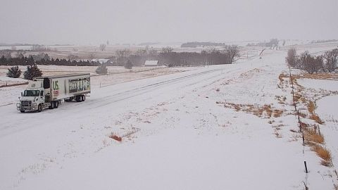
As the South braces for floods and tornadoes, the storm is expected to bring heavy snow, sleet and freezing rain across the Plains and Upper Midwest Tuesday, significantly impacting travel.
Residents in parts of Nebraska, South Dakota and Minnesota are likely to see intense snow rates of 1-3 inches per hour.
Over 15 million people are under winter weather alerts from Utah to Wisconsin.
Blowing and drifting snow on Tuesday may result in snow-covered roads and make it “hazardous, if not impossible” to travel, the National Weather Service warned.
Road conditions were already deteriorating Monday night in northwestern Iowa, northern Nebraska and eastern South Dakota, according to the National Weather Service in Omaha.
Roughly 200 miles of eastbound Interstate 80 in Wyoming, from Evanston to Rawlins, are closed due to the ongoing impacts of the storm, according to the Wyoming Department of Transportation. The department said westbound traffic is further blocked from the Rawlins section of I-80 to the I-25 junction in Cheyenne, which covers more than 120 miles.
“Snow [and] blowing snow to impact Wyoming roads into tonight,” an agency Facebook post read. “A high wind event will then create blowing [and] drifting snow, poor visibility and possible whiteout conditions Tuesday afternoon through Wednesday afternoon for sections of I-80, I-25, South Pass and various secondary roads!”
“If you can, please stay home. If you must travel, ensure you have an emergency kit in your car,” the National Weather Service in Sioux Falls told residents, saying travel will become difficult to impossible by Tuesday morning.
A vehicle winter emergency kit includes snacks and water, a battery-powered weather radio, flashlights and batteries, a first aid kit, a shovel and ice scraper, a jumper cable and other items.
Significant ice accumulations from freezing rain are expected, possibly over a quarter inch, from northeastern Nebraska through northwestern Iowa into southern Minnesota.
The freezing rain will also make conditions difficult for those on foot. Even a light glaze can make for slippery sidewalks and driveways. Accumulations more than 0.25 inches can cause scattered power outages and break tree limbs, the Weather Service says.
More News
A Test of Cloud-Brightening Machines Poses No Health Risk, Officials Say
The Full Guest List for Biden’s State Dinner With Kenya
In House Hearing, Republicans Demand Discipline for Student Protesters