


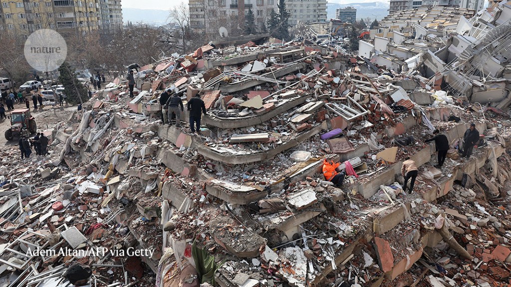
The magnitude-7.8 earthquake in Turkey last month destroyed many buildings, such as this one in the city of Kahramanmaraş.Credit: Adem Altan/AFP via Getty
Two decades ago, John McCloskey drew a red line on a map of southeastern Turkey to pinpoint where a large earthquake would probably strike. The only question was when.
The answer came last month, when a magnitude-7.8 shock hit the precise location that McCloskey and his team had identified. It struck at 4.17 a.m. local time on 6 February, when most people were asleep, and killed more than 50,000 residents in Turkey and neighbouring Syria.

One MRI for 4.7 million people: the battle to treat Syria’s quake survivors
McCloskey’s work shows both the promise — and limitations — of the science of earthquake forecasting. Although geologists have long attempted to provide warnings of the location, magnitude and exact time of future quakes, decades of research have shown that it’s probably impossible to predict when a geological fault will start to shake. “When you try to winnow it down to know what’s going to happen next, it tends to be a lesson in humility,” says Susan Hough, a geophysicist in the Earthquake Hazards Program at the United States Geological Survey (USGS). “The real focus in most of the world is not on prediction, but on assessing the hazard and the long-term rates of earthquakes.”
Today, researchers work on forecasting: identifying which fault segments are most dangerous and what size earthquakes they are expected to produce. Armed with that knowledge, policymakers can take steps to reduce death and destruction by, for example, requiring better building practices or urging local residents to prepare. Some regions of Japan, the United States and Turkey have developed early-warning systems that alert residents when an earthquake has started nearby. “In principle, you can get rid of seismic risk,” McCloskey says.
Danger zone
Turkey is a seismically active junction at which several pieces of Earth’s crust meet and grind against each other. In southeast Turkey and northern Syria, the Arabian plate is pushing north against the Anatolian plate, squeezing it to the west. But the shift isn’t one smooth movement. Instead, friction holds the plates in place, sometimes for centuries. When the stress overcomes the friction, the plates on either side of the fault line will shudder past each other, releasing tremendous energy in the form of an earthquake.
This has happened time and time again in Turkey — a history that allowed McCloskey and his colleagues to map the stresses along one of its major quake sources, the East Anatolian fault. Like other faults, it is divided into segments that slip at different times. When one segment shifts and shakes, it alters the stress on neighbouring sections of the same fault and other faults nearby. That increases the stress in some places, bringing them closer to failure, but relaxes stress on others — making them safer for the time being.
A fracture cuts across a road in the Kahramanmaraş region of Turkey after two strong earthquakes on 6 February.Credit: Utku Ucrak/Anadolu Agency via Getty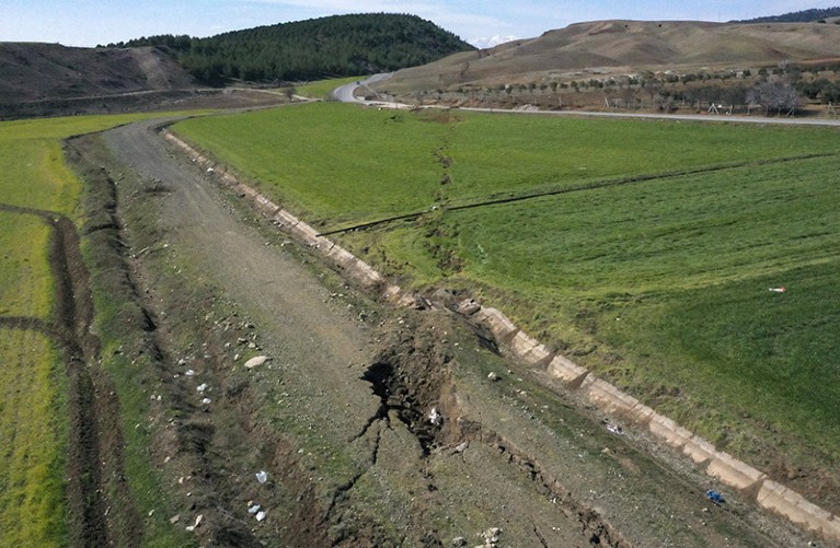
“They are not just randomly occurring earthquakes,” says Ross Stein, chief executive of Temblor, a company specializing in seismic hazard and risk assessment. “They are in a conversation. And that conversation is carried out through stress transfer.”
In 2002, McCloskey (now a geophysicist at the University of Edinburgh, UK) and his colleagues used this technique to diagnose regions on the East Anatolian fault that were highly stressed. With the help of historical records, the team incorporated the stress changes caused by ten earthquakes since 1822 into a model of ongoing plate movement. The modelling suggested that a region of the fault line south of Kahramanmaraş — the precise location and length of the fault that ruptured on 6 February — was at a heightened risk of giving way at some point in the future1. The team even knew that it would be devastating, forecasting a quake of magnitude 7.3 or higher. “The correspondence is remarkable,” McCloskey says.
It isn’t the first time that this method, technically known as Coulomb stress transfer, has accurately pinpointed an upcoming trembler. In 1997, Stein and his colleagues analysed the earthquakes that had already struck Turkey’s North Anatolian fault to estimate that the next might occur near the city of Izmit2. Two years later, that quake arrived — killing more than 17,000 people. In 2005, McCloskey and his colleagues calculated that the shift in stress after the 2004 Sumatra–Andaman quake in Indonesia might cause one in the Sunda trench west of Sumatra3. It came 12 days after the study was published. And in 2008, Shinji Toda from the Geological Survey of Japan in Tsukuba and his colleagues projected that the Wenchuan earthquake earlier that year in China would increase the stress of three adjacent faults4. In the following decade, two of those faults unleashed powerful earthquakes.
Added stress
It isn’t possible to use the technique everywhere. Because this model requires some knowledge of previous earthquakes, often centuries in the past, researchers can use it to assess only regions where the seismic history is well known. So it is most successful in forecasting aftershocks, which are typically smaller than main shocks. Still, there are many unknowns, and scientists are working hard to evaluate the model further.
In 2002, Tom Parsons, a geophysicist at the USGS, analysed more than 2,000 earthquakes with magnitudes of greater than 5.5 that occurred after — and near — quakes larger than magnitude 7. He found that 61% of the later quakes were associated with an increase in stress caused by the earlier ones5. The findings suggest that Coulomb stress transfer can accurately identify faults that are more likely to cause damaging quakes, he says. Then, in 2008, Parsons and his colleagues published a forecast following the Wenchuan earthquake with the intention of later evaluating the model’s performance6. That work is ongoing.
Why the Tongan eruption will go down in the history of volcanology
Today, Stein, one of the researchers who developed the theory about how forces shift after earthquakes7, estimates that the method has been used in 30,000 papers to explain two-thirds of our planet’s recent aftershocks and progressive main shocks. “That tells us this is not the only game in town,” Stein says. “Faults are grungy, messy features and they don’t behave as we would like them to.”
McCloskey’s model, for example, anticipated the location of the recent Turkey earthquake, but the shaking started on a much smaller branch of the fault and then spilt over to the main part, a pattern that Stein finds baffling. Another complication is that the main earthquake was also much larger than anticipated, probably because it re-ruptured a segment to the south that broke in 1822 and a segment to the north, which broke in 1893.
“This really underlines the problem of earthquake forecasting,” McCloskey says. “Even when we identify the place that is most dangerous, every earthquake is unique.”
Not long ago, seismologists thought they might be able to predict some quakes days or hours before they strike. Such hopes emerged from Parkfield, California, where earthquakes had rocked a small part of the San Andreas fault nearly every 22 years. Each of these quakes followed a smaller shock to the north. And hours before a strong quake near Parkfield in 1966, precursory movement had broken an irrigation pipeline that crossed the fault.
“In 1966, earthquake prediction looked like it was ours to have,” Stein says. Before the next anticipated earthquake, geologists wired the area with hundreds of seismometers — hoping to find some harbinger that could be used to forecast future quakes. But when the next quake hit, researchers saw no warning signs.
Other precursors have similarly vanished. Over the years, scientists have analysed increasing amounts of radon in local water, electromagnetic signals from Earth’s crust and even odd animal behaviour. But none of these potential precursors stood up to statistical tests. “Despite all kinds of startling, promising shreds of evidence, we haven’t made an iota of progress toward actually predicting earthquakes,” Stein says.
McCloskey doesn’t think that it will ever happen. And Hough, who wrote a book called Predicting the Unpredictable (2009), argues that most geologists in the West don’t even work on it — at least, not any more. “We know how unlikely it is that suddenly something is going to show up that we can see before every big earthquake,” Stein says.
Even though geoscientists can’t predict quakes with any precision, many researchers say it is possible to prevent much of the death and destruction from these natural disasters.
After the 1999 earthquake in Izmit, Aykut Barka, a geologist at Istanbul Technical University, warned that the increased stress could trigger a similar rupture near Düzce, a town roughly 100 kilometres east8. His work persuaded the authorities to close school buildings that had been damaged by the Izmit shock. When a magnitude-7.1 earthquake struck the city 2 months later, the buildings collapsed.
Early warnings
Earthquake forecasting could help in other regions as well. California, for example, which is home to the massive San Andreas fault, has implemented the beginnings of an early-warning system that relies on networks of seismometers to detect the very start of a quake. That can provide seconds or minutes of advance notice to Californians to ‘drop, cover and hold on’ while automatically triggering life-saving measures such as slowing trains to a stop.

How dangerous is Africa’s explosive Lake Kivu?
In 2002, Turkey implemented an early-warning system in Istanbul that will slow trains, open lift doors and shut down critical processes in factories in the case of an earthquake. The country has also implemented building codes, but many scientists were concerned that they weren’t being enforced rigorously enough. Mustafa Erdik, a retired civil engineer at Boğaziçi University in Istanbul and president of the Turkish Earthquake Foundation, agrees that this was the case — arguing that ignorance, incompetence and implicit collusion between architects, inspectors and builders were at fault.
That makes February’s aftermath particularly painful for those researchers who have been sounding the alarm for years. “You put a red line on a map, and you understand that means lots of people are going to be killed and their houses destroyed,” McCloskey says.
“The Turkey earthquake to me is, of course, a complete tragedy,” he says. Yet McCloskey is hopeful that we will learn from it. If we do, the next red line he draws on a map will not necessarily equal a catastrophic loss of lives.
More News
Author Correction: Bitter taste receptor activation by cholesterol and an intracellular tastant – Nature
Audio long read: How does ChatGPT ‘think’? Psychology and neuroscience crack open AI large language models
Ozempic keeps wowing: trial data show benefits for kidney disease