


CNN
—
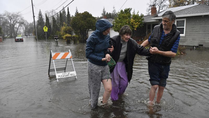
Northern California was inundated with widespread flooding and power outages as a powerful atmospheric river barreled into the region, forcing water rescues, several highway closures, evacuation warnings and shelter-in-place orders.
Despite the issues, the moisture is a bit of relief for drought-stricken California, which saw the driest beginning of the year on record and ended 2022 with drenched roadways, flooding rivers and thick mountain snow.
How much the parade of storms will make a dent in California’s drought conditions, however, remains to be seen.
Meanwhile the storm, which also brought strong winds, knocked out power to more than 300,000 homes and businesses across California and Nevada as of early Sunday, according to Poweroutage.US.
And as streets flooded and river water levels rose, the storm also forced residents of several small communities in northern California out of their homes on New Year’s Eve as evacuation orders and warnings were issued.
On top of urban flooding, several rivers began overflowing, including the Cosumnes and Mokelumne rivers and the Mormon Slough, according to the National Weather Service in Sacramento. Flood warnings were issued for the southern Sacramento Valley and Sierra foothills.
At one point Saturday, officials ordered residents in Wilton – roughly 20 miles from Sacramento – to leave the area immediately, warning that rising water may spill over onto roadways and cut off access to leave the area. Just about two hours later, Wilton residents were told to shelter in place after water made roads “impassable.”
Three communities near the city of Watsonville were also told to evacuate by the Santa Cruz County Sheriff’s Office due to creek flooding, while the rising San Lorenzo River waters prompted evacuations in the communities of Paradise Park and Felton.
In San Ramon, police used an armored rescue vehicle to evacuate residents from floodwaters.
“Flooding impacts continue to escalate as this rain continues with too many road closures to count at this point,” NWS said Saturday, telling residents to stay put amid reports of rock and mudslides across the foothills and road closures across the Sierra passes.
Sacramento Metropolitan Fire District crews were kept busy on Saturday, performing water rescues and responding to fallen trees on homes and cars, and to drivers whose vehicles became disabled after they drove through standing water, officials said.
Calling it “Stormageddon,” the Amador County Sheriff’s Office shared an image of cars up to their doorhandles in floodwaters and said there’s been reports of flooding, mudslides and trees blocking roadways.
Highway 50 was reopened just after midnight, hours after a section between Pollock Pines and Meyers was closed due to flooding from the American River, while another section was closed over Echo Summit for avalanche control work.
Interstate 80 was also partially closed near the Nevada line midday Saturday “due to multiple spinouts over Donner Summit,” according to the California Department of Transportation.
US Highway 101 – one of California’s most famous routes – was also temporarily closed in both directions in South San Francisco with California Highway Patrol reporting “water is not receding due to non-stop rainfall & high tides preventing the water to displace.”
In Sacramento County and adjacent areas, residents were advised to avoid travel as wind gusts of up to 55 mph toppled trees and covered roads with debris, according to a tweet from the National Weather Service in Sacramento.
The county proclaimed a state of emergency, saying the atmospheric river has caused “significant transportation impacts, rising creek and river levels and flooding” in the Wilton area.
An atmospheric river is a long, narrow region in the atmosphere which can transport moisture thousands of miles, like a fire hose in the sky.
Downtown San Francisco received 5.46 inches Saturday, meaning it was on track to become the second wettest day on record for the area, according to the National Weather Service in the Bay Area.
This heavy rainfall is expected to slide southward to Southern California on Saturday and Sunday, accompanied by gusty winds of 30 to 50 mph.
As some parts of Northern California deal with heavy rainfall, mountain areas have received thick snowfall accumulations.
A winter storm warning is in effect until 4 a.m. Sunday in the Sierra Nevada mountains from Yosemite National Park to Tulare County, where the Weather Service warned travel could be very difficult to impossible.
Snow accumulations of 1 to 2 feet were expected above 7,000 feet, and isolated accumulations of 5 feet were possible above 9,000 feet, the Weather Service said.
The UC Berkeley Central Sierra Snow Lab reported 7.5 inches of snow per hour between 4 and 5 p.m. Saturday in Soda Springs, about 30 miles from Lake Tahoe, sharing video of thick snow blanketing the area.
The lab said it had unofficial measurements of more than 30 inches of snow on Saturday.
Over a foot of new snow fell at Mammoth Mountain’s Main Lodge Saturday, the ski resort said on Facebook, adding that work will take place across the mountain since all lifts were coated in ice and “avalanche danger is extremely high.”
At the Nevada State line and Colfax, CHP reported “dangerous and treacherous” driving conditions with dozens of vehicles stuck on the I-80 and county roads.
“Caltrans, CHP and tow operators spent New Year’s Eve pulling out dozens of stranded vehicles,” the California Department of Transportation said.
More News
School Employee Arrested After Racist Deepfake Recording of Principal Spreads
School Employee Arrested After Racist Deepfake Recording of Principal Spreads
Arizona Republicans Who Supported Repealing an Abortion Ban Face Blowback